button to add them to your planner, then Print or Download your itinerary for the driving directions to each stop on your trip plan.


 Create a Trip!
summer 2013
from users
15 items | Created 01/23/2013
Use/Customize | Download | Print

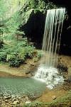
Situated in a remote section of the northern Cumberland Plateau of Tennessee, Pickett CCC Memorial State Park is known for its geological, botanical, and scenic wonders.

The Big South Fork National River and Recreation area boasts miles of scenic gorges and sandstone bluffs and provides visitors with wide range of outdoor recreational activities such as hiking, camping, mountain biking, fishing, swimming, paddling,and horseback riding.
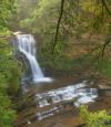
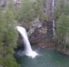
Droping over 60 feet from a rock ledge, Northrup Falls of Colditz Cove State Natural Area is one of the most photogenic waterfalls of the Cumberland Plateau. It flows through a scenic narrow gorge along Big Branch Creek amidst some of the largest old growth stands of hemlock and white pines that can be seen in the plateau region.
Frozen Head State Park and Natural Area is situated in the beautiful Cumberland Mountains of Tennessee. Frozen Head, elevation of 3,324, is one of the highest peaks in Tennessee west of the Great Smoky Mountains and is home to small but photogenic and accessible - Debord Falls.

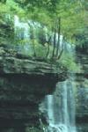
Piney Falls State Natural Area is a 440-acre natural area insulating the 80 ft. Piney Falls and a pristine forestland featuring creeks, deep gorges, waterfalls and old growth forest. This National Natural Landmark is an easily accessible waterfall requiring a short hike.
Stinging Fork Falls is a 783-acre natural area located in Rhea County. It is named for the 30-foot waterfall located within the Stinging Fork gorge that attracts hikers, photographers, and whitewater kayakers. The Stinging Fork Falls trail terminates at the bottom of the falls about 1.5 miles from the parking area, making this a 3 mile round trip hike.
This 2,259-acre natural area located in Rhea County is home to the 80 ft. tall Laurel Falls and the 35 ft. Snow Falls. Both of these waterfalls can be reached with a 7 mile round-trip hike that is a segment of the greater Cumberland Trail. It is a very popular destination for simmers and is rated a class V for paddlers.
Cummins Falls was recently dedicated as the 54th State Park in Tennessee. It cascades 50 feet into one of the best swimming holes in the southeast. The hiking to the base of the falls was previously quite risky and mostly accessible to a younger more adventurous crowd, but work is currenlty underway to make this swimming hole and the falls accessible to all.
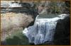
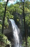
Burgess Falls cascades 130 feet into a deep gorge and can be viewed via a short trail from the state park's parking lot. The trail to deck overlooking the waterfall is approcimately 3/4 of a mile from the parking lot with another half a mile to reach the base of the falls, so a visit could be made in an hour and a half.
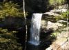
Tennessee's Scott’s Gulf region has over 100 miles of publicly accessible hiking trails, including Virgin Falls - a 110 foot waterfall that is followed by a number of other impressive waterfalls such as Big Laurel, Sheep Cave, and Big Branch falls. It's a strenuous hike to get there, but it's an all time favorite.
A paradise of more than 20,000 acres sprawled across the eastern top of the rugged Cumberland Plateau, Fall Creek Falls State Park is one of the most scenic and spectacular outdoor recreation areas in America.
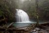
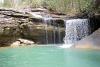
The Upper and Lower Greeter Falls can be accessed from the Stone Door entrance of the Savage Gulf State Natural Area in Beersheba Springs. The hike is a 2 mile round trip demanding some agility and strength, but you are guaranteed a cool swim in the blue hole even in the driest, hottest summer days.
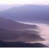
Cumberland Gap was the first great gateway to the west through the Appalachain Mountains. This park hosts an amazing combination of natural beauty and rich history with over 85 miles of hiking trails and some of the most dramatic views in all of Appalachia.
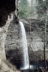
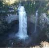
Ozone Falls is a 43-acre natural area in Cumberland County. It receives heavy visitation because of its close proximity to Interstate 40. Ozone Falls plunges 110 feet over a sandstone cap rock into a deep blue, rock-strewn pool.
Foster Falls Small Wild Area centers on a 60-foot waterfall, visible from sandstone overlooks and surrounded by 178 acres of lush flora, including mountain laurel, azalea, and hemlock. Foster Falls is an access point for the famed Fiery Gizzard Trail - a 12 mile trail that leads hikers to Grundy State Natural Area, and it is a very popular rock climbing destination.