button to add them to your planner, then Print or Download your itinerary for the driving directions to each stop on your trip plan.


 Create a Trip!
 Back to map
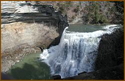
Burgess Falls State Park
The Best Waterfalls
Burgess Falls cascades 130 feet in a deep gorge and viewed and accessed via a short trail from the state park's parking lot. The trail to deck overlooking the waterfall is approcimately 3/4 of a mile with another half a mile to reach the base of the falls, so a visit could be made in an hour and a half. It is by far one of the most popular parks and waterfalls in the state of Tennessee.
Burgess Falls is named after Tom Burgess, a Revoluntionary War veteran who setttled along this section of the Falling Water River in the 1790s. A 1.5 mile trail loop follows the bluffs along the south bank of the gorge, starting at Falling Water Cascades and ending at a platform overlooking Burges Falls. Two other falls are also visible from the trail. A stairway leads down to the overhang of Burgess Falls and continues down into the gorge.Things to do in TN's Burgess Falls State Park
Hiking
The 1.5-mile round-trip River Trail/Service Road Loop is a moderately strenuous but short hike taking visitors past four waterfalls on the Falling Water River. The four waterfalls are 20' , 30', 80' , and 130' in height. Most people prefer to hike back to the parking lot along the service road after a hike to the viewing deck or to the base of the large falls.
Fishing
Fishing is open year-round and the most common catches are large and small mouth bass, brim and carp. The most popular fishing sites are along the lake, below the dam and below the main falls. The waters of Center Hill Lake reach the base of Burgess Falls.
For More Information
4000 Burgess Falls Dr.
Sparta, TN 38583
Phone: (931) 432-5312
Website: http://tn.gov/environment/parks/BurgessFalls/
Nearby Attractions
 Appalachian Center for Craft, 7.9 miles away
- Sparta Drive-In, 8.1 miles away
- DelMonaco Winery and Vineyards, 8.3 miles away
 White County Fairgrounds, 8.8 miles away
 Sharp Lodge, 8.9 miles away
Relevant Itineraries
- Must Visit - Created 06/13/2017
- Fall 2016 - Created 09/29/2016
- Fall2016 - Created 09/29/2016
- Fall2016 - Created 09/29/2016
- Fall 2016 - Created 09/29/2016
- Cumberland Plateau fall 2016 - Created 09/29/2016
- TN _falls#1 - Created 08/13/2016
- S&S - Created 08/09/2016
- Mel - Created 07/24/2016
- vacation - Created 09/30/2014
- TOUR - Created 09/10/2014
- TOUR - Created 09/10/2014
- Tennesse - Created 08/01/2014
- falls - Created 07/30/2014
- crossville tn - Created 03/03/2014
- Cumberland Plateau - Created 02/17/2014
- Tenessee - Created 12/18/2013
- Cumberland Water Falls - Created 10/16/2013
- Nashville3 - Created 09/24/2013
- Nashville2 - Created 09/03/2013
- Nashville - Created 09/01/2013
- zzzzz - Created 07/31/2013
- Vacation 2013 - Created 06/07/2013
- cumberlands - Created 05/29/2013
- cumberlands - Created 05/29/2013
- Tenn - Created 05/20/2013
- trip to tennessee - Created 02/17/2013
- summer 2013 - Created 01/23/2013
- summer 2013 - Created 01/23/2013
- Summer 2013 - Created 01/23/2013
- WFalls_CrossCook - Created 11/28/2012
- Fall Break 2012 - Created 10/09/2012
- vac - Created 09/18/2012
- Tenn. Trip - Created 08/31/2012
- Nature Near Hippie Jack's - Created 08/30/2012
- Hiking 30 Miles from Cookeville - Created 08/24/2012
- Jamestown TN Trip - Created 08/11/2012
- waterfalls in TN - Created 08/11/2012
- cumberland - Created 08/02/2012
- birthday trip - Created 08/01/2012
- Best Waterfalls Trip - Created 07/11/2012
- Fall Break - Created 07/10/2012
- Lake & Waterfall Weekend - Created 06/21/2012
- Weekend at the Falls - Created 06/12/2012
- hiking - Created 05/31/2012
- Ross's Trip - Created 05/05/2012
- Wine on the West Side Trip - Created 04/26/2012