button to add them to your planner, then Print or Download your itinerary for the driving directions to each stop on your trip plan.


 Create a Trip!
 Back to map
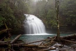
Stinging Fork Falls State Natural Area
Best Waterfalls
Stinging Fork Falls is a 783-acre natural area located in Rhea County. It is named for the 30-foot waterfall located within the Stinging Fork gorge. The creek flows over the fan shaped falls, then quickly slips through chutes, and tumbles over cascades below the falls.
The gorge contains a second growth mixed mesophytic forest community. Steep cliffs may be found along the smaller bluffs that descend into the gorge. An oak-pine forest can be found along the gorge bluff. Indian Head Point provides a view of the gorge and creek 160 feet below. Much of the upland area between the parking area and gorge had been planted by Bowater in loblolly pine, and has since been removed due to heavy southern pine beetle impact.
This area is undergoing hardwood succession and is currently home to numerous early successional bird species such as Bob white Quail, Field Sparrows, Indigo Buntings, Blue Grosbeaks, and American Goldfinches. The Stinging Fork Falls trail terminates at the bottom of the falls about 1.5 miles from the parking area making this a 3 mile round trip hike.
Things to do at Stinging Fork Falls State Natural Area
Hiking
The 1.5 mile Stinging Fork Falls trail has now become a segment of the Cumberland Trail and they have a full trail description on their website. View the full decription here.
Swimming
The pool below the waterfall offers a great place to cool off on a hot summer day and this park site isn't heavily visited, so you might just have the entire place to yourself or your group.
Paddling
Taking your kayak through Stinging Fork and over the falls is now recommended for beginners and even experienced kayakers shy away, so make sure and get as much beta as possible before making a run. You can read more about this run on the American Whitewater Website.
No Camping :(
For More Information
Shut in Gap Road
Spring City, Tennessee 37381
Phone: (423) 566-2229
Website: http://www.tennessee.gov/environment/na/natareas/stinging/
Nearby Attractions
 Piney River Segment of the Cumberland Trail, 3.4 miles away
 Red Barn Restaurant and Grill, 4.3 miles away
- Piney Falls State Natural Area, 5.8 miles away
 Grandview Mountain Cottages, 7.5 miles away
 Swafford Chapel & Cemetery , 7.9 miles away
Relevant Itineraries
- vacation - Created 01/20/2022
- Reneonk 1 - Created 02/16/2018
- SpringCity ToDo - Created 07/31/2017
- Cumberland Plateau - Created 05/28/2017
- Fairfield Glad - Created 10/28/2016
- TN Falls - Created 09/28/2016
- TN _falls#1 - Created 08/13/2016
- Mel - Created 07/24/2016
- Tenn sept 2014 - Created 08/23/2014
- Tennesse - Created 08/01/2014
- 127 Yardsale - Created 06/27/2014
- 5-31-14 - Created 05/28/2014
- Family Fun - Created 05/21/2014
- Cumberland Plateau - Created 02/17/2014
- Tenessee - Created 12/18/2013
- oct2013 - Created 10/29/2013
- tenn - Created 08/28/2013
- trip to tennessee - Created 02/17/2013
- summer 2013 - Created 01/23/2013
- summer 2013 - Created 01/23/2013
- Fall Break 2012 - Created 10/09/2012
- Jamestown TN Trip - Created 08/11/2012
- Cumberland Waterfalls - Created 08/11/2012
- waterfalls in TN - Created 08/11/2012
- cumberland - Created 08/02/2012
- TN's 127 Yard Sale Nature Sites - Created 07/20/2012
- Best Waterfalls Trip - Created 07/11/2012
- Grandview Waterfall Weekend - Created 04/26/2012