button to add them to your planner, then Print or Download your itinerary for the driving directions to each stop on your trip plan.


 Create a Trip!
 Back to map
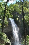
Laurel Snow State Natural Area
Best Waterfalls
This 2,259-acre natural area located in Rhea County is home to the 80 ft. tall Laurel Falls and the 35 ft. Snow Falls. Both of these waterfalls can be reached with a 9 mile round-trip hike that is a segment of the greater Cumberland Trail. It is a very popular destination for simmers and is rated a class V for paddlers.
The natural area also has scenic creeks, steep gorges, geologic features, a small stand of virgin timber, and a wide variety of plants. Buzzard Point and to Snow Falls can be hiked to by following the trail as it forks to the left going west. The trail to the right leads to Raven Point, which overlooks Laurel Snow. The trail eventually climbs to the top of the falls.
Laurel-Snow State Natural Area is managed by the Cumberland Trail State Scenic Trail, and the area includes trailhead parking and an open section of the Cumberland Trail. Backcountry camping is available by permit only call 423-566-2229 or go to www.cumberlandtrail.org about camping opportunities.
Things to do at Laurel Snow State Natural Area
Hiking
This moderate 9 mile round-trip splits after 1.5 miles to access Snow Falls or the 80 ft. Laurel Falls. The best online trail description we could find is on LocalHikes.com.
Swimming
This is a popular place for swimming and has numerous swimming holes but swimmers need to beware of how quick the waters of this creek can rise in a thunderstorm up higher in the watershed.
Paddling
As a class V, American Whitewater's website recommends that none of this 2.65 mile run is paddled with careful planning. It offers some of the Southeast's greatest paddling for those experienced and skilled enough to attempt it. Read more at the American Whitewater Website
Camping
Available by registration at the trailhead or online
For More Information
100 Pockett Wilderness Road
Dayton, Tennessee 37321
Phone: (423) 566-2229
Website: http://www.tennessee.gov/environment/na/natareas/laurelsnow/
Nearby Attractions
 Ellie's Catfish Cafe, 1.1 miles away
 Scopes Trial Museum & Rhea County Courthouse, 1.5 miles away
- Dayton Coffee Shop, 1.6 miles away
- Jacob Myers Deli, 1.6 miles away
 ArtCrafters, 1.6 miles away
Relevant Itineraries
- TN Falls - Created 09/28/2016
- Mel - Created 07/24/2016
- 127 Yardsale - Created 06/27/2014
- August trip - Created 03/17/2014
- Cumberland Plateau - Created 02/17/2014
- Tenessee - Created 12/18/2013
- Vacation 2013 - Created 06/07/2013
- summer 2013 - Created 01/23/2013
- summer 2013 - Created 01/23/2013
- Jamestown TN Trip - Created 08/11/2012
- Cumberland Waterfalls - Created 08/11/2012
- waterfalls in TN - Created 08/11/2012
- TN's 127 Yard Sale Nature Sites - Created 07/20/2012
- Best Waterfalls Trip - Created 07/11/2012
- dunlap - Created 06/22/2012